

Dissecting the Rafting Trail Telaga Waja: Check Now!
Rafting Trail Telaga Waja is a popular destination for travelers looking for an exciting white water rafting experience in East Bali. Located near the slopes of Mount Agung, Telaga Waja River offers a scenic route with flowing currents, rapids, and beautiful natural surroundings. Depending on the operator and selected package, the rafting journey is commonly advertised at approximately 12 to 16 kilometers and may take around 2 to 2.5 hours on the water.
Along the way, participants may enjoy views of terraced rice fields, rocky riverbanks, green vegetation, and the surrounding countryside. The river features different sections, ranging from flowing stretches to rapids that require coordination and attention. These changing conditions make the journey an engaging outdoor activity for both first-time participants who meet the operator’s requirements and those with previous rafting experience.
Rafting at Telaga Waja is not only about navigating the river but also about appreciating the natural landscape along the route. Depending on the selected package, facilities such as safety equipment, guide services, shower areas, and meals may be available after the activity. Participants should confirm the facilities and package inclusions with their chosen operator before booking.
Read More: Rafting in Telaga Waja is Amazing Experience

Maps for Rafting Trail Telaga Waja
Understanding the general route can help participants picture what to expect during their rafting adventure. Some rafting trips in the Telaga Waja area begin around Muncan Village, although the exact starting point, finishing point, and route can differ between operators.
The early section of the journey introduces participants to the river’s movement. Depending on water levels and route conditions, this part may include flowing stretches and smaller rapids, giving the group an opportunity to become familiar with the raft and follow the guide’s paddling commands.
Further downstream, the river may feature more active rapids, bends, and rocky sections. Participants need to coordinate their paddling and listen to the guide as the raft navigates changing currents. Some routes also pass natural features such as small waterfalls, cliffs, and bridges, adding variety to the surrounding scenery.
One feature often associated with Telaga Waja rafting is a descent near the end of certain routes. It is sometimes described as an approximately 3–4 meter drop, although the exact height and whether it is included depend on the operator and selected route. Participants should confirm this feature before booking rather than assuming every rafting package includes it.
A route map provided by the operator is the best way to understand the actual starting point, main sections, stopping areas, and finishing location for a particular trip.
Most Exciting Rapids Along the Route
Telaga Waja River has sections with different current patterns and levels of challenge. Some informal names may be used by guides or operators to describe particular features, but these names are not necessarily official or shared by every rafting provider.
The following descriptions explain the types of river features participants may encounter:
A. Five Rock Rapids
Rock formations can create changes in water movement and require the raft to follow a suitable path through the river. Navigating these sections depends on the guide’s direction and the group’s coordination.
B. Sharp Bend Rapids
Some parts of the river include bends where the current changes direction. These sections require the guide to navigate carefully while participants follow paddling instructions to help the raft move through the turn.
C. Waterfall or Drop Section
Certain Telaga Waja rafting routes feature a noticeable descent that is often described as a mini waterfall or artificial drop. This section can create an exciting moment during the journey, but its availability and characteristics depend on the selected route and river conditions.
D. Zig-Zag Rapids
Some river sections may require the raft to move through a series of changing directions. These areas make coordination important, as participants need to respond to the guide’s commands while the raft moves through the current.
E. Final Rapids
The final part of a rafting route may still include flowing water or smaller rapids before reaching the finishing point. The river conditions can vary, so the end of the journey should not automatically be assumed to be calm.
The Sensation of Passing a Mini Waterfall
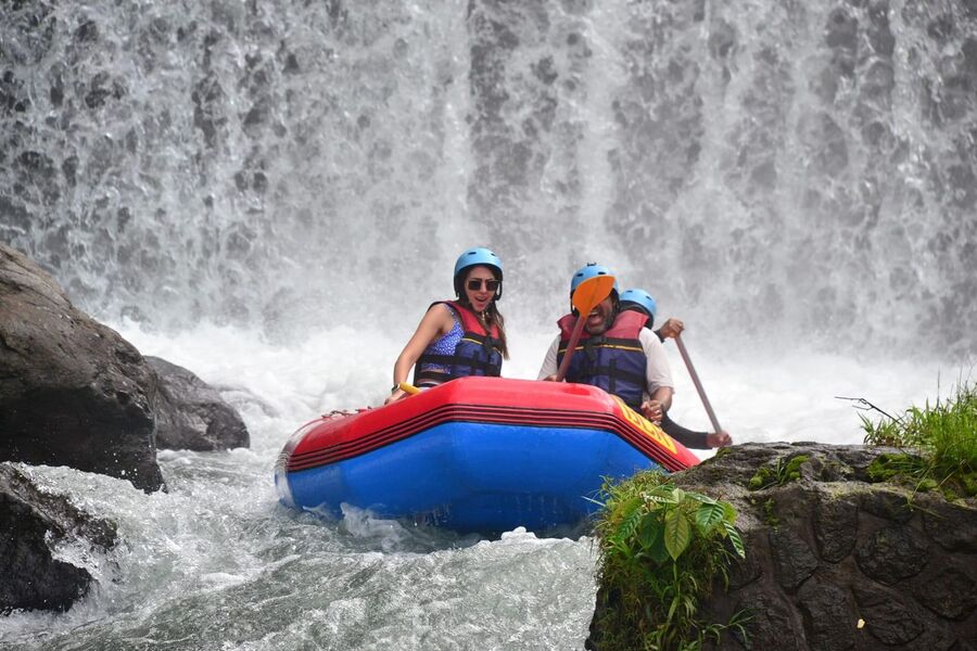
One of the features often highlighted in discussions about Telaga Waja rafting is the descent sometimes described as a mini waterfall. On routes that include this section, the raft approaches a drop where the water moves over a noticeable change in elevation.
Passing through this area can be an exciting part of the adventure. The movement of the raft, sound of the water, and surrounding river landscape create a memorable experience for participants.
The descent is sometimes advertised as approximately 3–4 meters high, but participants should confirm the actual feature with the operator. It should not be assumed that every route includes the same drop or that its conditions remain identical throughout the year.
This section may also be used as a photography point by some operators. However, photographs should only be taken by designated photographers or participants when it is safe to do so. Always follow the guide’s instructions and avoid handling personal devices while navigating challenging sections.
Challenging Bends and Resting Points
Apart from rapids and river drops, the route may include bends and suitable stopping areas. These features add variety to the journey and may provide opportunities for participants to appreciate the surroundings.
Some operators or guides may use informal names to describe particular bends and stopping locations. The names below should therefore be treated as route descriptions rather than guaranteed official landmarks.
A. Snake Bend
A winding section of the river may be informally described as a snake-like bend because of its curved shape. Navigating a bend requires the guide to assess the current and direct the raft through the appropriate path.
B. V-Curve Bend
A sharper turn may create a change in the direction of the raft. Participants should pay attention to the guide’s commands and coordinate their paddling when instructed.
C. Bamboo Cliff Rest Point
Some routes may include a suitable stopping area near rocky riverbanks or vegetation. If a route has a resting point near bamboo growth, participants may have an opportunity to pause and enjoy the surroundings. The availability of this particular location should be confirmed with the operator.
D. Coconut Spot Rest Point
A stopping area where refreshments are available may be included in certain rafting arrangements. However, fresh coconut water or other refreshments should not be assumed to be part of every trip. Check with the operator to find out whether a refreshment stop is included in the selected package.
Dissecting The Rafting Trail Telaga Waja: Check Now!
Best Photo Spots Along the Rafting Trail Telaga Waja
The natural surroundings of Telaga Waja River provide several interesting opportunities for photography. From river drops to green landscapes, different sections may offer memorable backgrounds for documenting the adventure.
Here are some photo opportunities that may be available along certain routes:
A. Mini Waterfall or 4-Meter Drop
The descent section is often considered one of the most visually striking features of routes that include it. A photograph of the raft approaching or passing the drop can capture the excitement of the journey. The actual height and availability of this feature should be confirmed with the operator.
B. Green Rice Fields Along the River
Rice fields and cultivated landscapes may be visible from certain parts of the river. These green surroundings offer a glimpse of Bali’s countryside and create a natural backdrop for rafting photographs.
C. Rock Cliffs and Lush Trees
Some sections of the route pass rocky riverbanks, cliffs, and dense vegetation. These natural features can create an interesting contrast with the river and the raft, giving photographs a more adventurous atmosphere.
D. Traditional Bamboo Bridge
A bamboo bridge may be visible along certain sections of the river, depending on the selected route. Its presence can add a distinctive countryside element to the scenery. However, not every rafting trip is guaranteed to pass the same bridge.
Participants who want professional photographs should ask whether the operator provides a documentation service and whether the cost is included in the package. Personal cameras and phones should only be used when it is safe and permitted by the guide.
Conclusion
Exploring the rafting trail at Telaga Waja offers an exciting way to experience the natural beauty and changing river conditions of East Bali. From flowing sections and challenging bends to possible waterfall features and scenic riverbanks, the journey provides a variety of experiences along the route.
The advertised distance, duration, rapids, stopping areas, and special features can differ depending on the rafting operator and selected package. For this reason, checking the route map and confirming specific features before booking will help participants understand what their trip includes.
Whether you are interested in navigating the rapids, experiencing a river descent, or enjoying the surrounding landscape, Telaga Waja Rafting can be a memorable outdoor activity in Bali. Prepare properly, listen to your guide, and enjoy the journey while respecting the river environment.
Frequently Asked Questions About the Telaga Waja Rafting Trail
1. Does every Telaga Waja rafting operator use the same route map?
No. Starting points, finishing locations, route distances, and stopping areas may differ between operators. Some providers may use similar river sections, but participants should request the route information for their specific package before booking.
2. Are names such as Five Rock, Snake Bend, and Bamboo Cliff official river landmarks?
Not necessarily. Names like these may be informal descriptions used by particular guides, operators, or promotional materials. They should not be treated as standardized names that every rafting provider recognizes.
3. How can I find out whether my rafting package includes the 3–4 meter drop?
Ask the operator directly whether the selected route passes through the descent section. It is also useful to confirm whether the feature is accessible under the river conditions expected on your activity date.
4. Can the rafting route change on the day of the activity?
Yes. Operators may adjust the route or activity arrangements depending on river conditions, weather, water levels, and operational considerations. The guide’s assessment on the day should take priority over a general route description.
5. Are resting points fixed locations along the Telaga Waja route?
Not necessarily. Suitable stopping areas depend on the river conditions, route, and operator’s arrangements. Some routes may include designated places to pause, while others may have different stopping arrangements.
6. Can participants stop at a photo spot whenever they want?
No. Participants should not ask the guide to stop at an unsafe location or leave the raft without permission. Photography stops can only take place when the guide determines that the location and river conditions are suitable.
7. How can I tell which section of the river I am approaching during the trip?
The rafting guide is the best source of information about the route. Guides may explain upcoming bends, rapids, or other features during the journey. Participants should listen to these explanations and follow any instructions given before reaching each section.
8. What route information should I confirm before making a reservation?
Ask about the starting and finishing points, approximate distance, time on the water, whether the drop section is included, and whether the package has designated stopping areas. You can also ask about photography services and other facilities available after the trip. This helps you compare packages based on the actual route rather than promotional descriptions alone.